The Importance of the Parallels and Meridians

The Parallels and Meridians
Define the parallels and meridians
Parallels are more commonly known as latitudes. Latitude refers to the angular distance North or South of the equator calibrated in degrees, minutes and seconds, measured from the centre of the Earth.
The equator is given a value of 0º. It is an imaginary line which divides the Earth into two hemispheres (northern hemisphere and southern hemisphere). The Northern hemisphere has latitude of 90ºN and the Southern hemisphere has latitude of 90ºS. All other latitudes are drawn north or south, parallel to the equator. A particular latitude, say 60ºN joins all points on the surface of the Earth which make an angle of 60º from the centre of the Earth (the equator). Any circle drawn around the Earth, parallel to the equator, is a parallel of latitude. Table 1.3 shows important parallels and figure 1.18 shows the location of these parallels on the Earth’s surface.
The equator is given a value of 0º. It is an imaginary line which divides the Earth into two hemispheres (northern hemisphere and southern hemisphere). The Northern hemisphere has latitude of 90ºN and the Southern hemisphere has latitude of 90ºS. All other latitudes are drawn north or south, parallel to the equator. A particular latitude, say 60ºN joins all points on the surface of the Earth which make an angle of 60º from the centre of the Earth (the equator). Any circle drawn around the Earth, parallel to the equator, is a parallel of latitude. Table 1.3 shows important parallels and figure 1.18 shows the location of these parallels on the Earth’s surface.
Table 1.3 important parallels
| Parallel | Latitude |
| North Pole | 90°N |
| Arctic Circle | 66 ½ °N |
| Tropic of Cancer | 23 ½ °N |
| Equator | 0° |
| Tropic of Capricorn | 23 ½ °S |
| Antarctic Circle | 66 ½ °S |
| South Pole | 90°S |
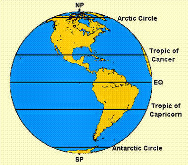
Fig 1.18 Location of parallels on Earth
Meridians are commonly known as longitudes. A longitude is an imaginary line drawn on the map from the North Pole to the South Pole. Meridians are numbered in degrees East or West of longitude 0°, called Greenwich Meridian (because it passes through a town in England called Greenwich). It is also known as the Prime Meridian because it is the line of reference from which all other meridians are established.
A longitude, therefore, refers to angular distance measured in degrees East and West of the Greenwich Meridian. The Prime Meridian runs through the poles and the Greenwich observatory near London. All lines of longitude are in equal length and divide the Earth into two equal semi circles. There are 360° in a circle, with 180° lying east of the Greenwich Meridian and the other 180° west of Greenwich.
The Greenwich line has been chosen by convention (meaning that any other line could have served the same purpose).
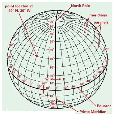
Fig 1.19 Longitudes and latitudes
How Latitudes and Longitudes are Determined
Describe how latitudes and longitudes are determined
Determining latitudes
All latitudes are determined in reference to the equator (0°). The angle of latitude is determined by measuring angles from the centre of the Earth and from the equatorial plane towards the North or South Pole. It is stated in degrees north or south of the equator, e.g., 30°S, 15°N, 45°N, etc.
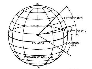
Fig 1.20 Determining latitudes
Determining longitudes
The angle of longitude is determined by measuring the angle from the centre of the Earth, along the equatorial plane towards the East or West of Prime Meridian. The value of a latitude is expressed as the angle between the Prime Meridian and the point on any latitude East or West of the Prime Meridian, e.g. 45°E, 30°W, etc.
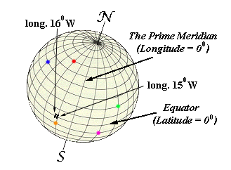
Fig 1.21 Determining longitudes
Importance of a Great Circle
Explain the importance of a great circle
A Great Circle is any circle that circumnavigates the Earth and passes through the centre of the Earth. A great circle always divides the Earth into halves. Thus, the Equator is the only latitude that is a great circle since it divides the Earth into two equal halves; and all lines of longitude are great circles.
Countless great circles can be drawn around the Earth so long as they pass through the centre of the Earth and that they divide the Earth into two equal halves.
Importance of great circles
The shortest distance between any two points on the Earth lies along a great circle passing through the two points. For this reason, great circles are used in plotting routes for ships crossing large stretches of ocean water and aircraft flying great distances in space. Captains and pilots of ships and aircraft, respectively, travel by following great circles in order to save fuel and time because by following the great circle they travel the shortest possible distance to reach their destinations.
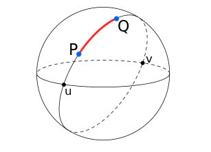
Fig 1.22 Great circles
Importance of Parallels and Meridians
Discuss the importance of parallels and meridians
Longitudes and latitudes are very important to any geographer or map reader. The importance of longitudes and latitudes include the following:
- They are used by pilots and sailors to guide their paths as they steer the planes and ships.
- When used together, longitude and latitude define a specific location through geographical coordinates (Fig 1.23).Each location on Earth has its unique latitude and longitude. For example, the location of a point shown on figure 1.23 below is 40°N,60°W.
- Longitudes enable geographers to calculate the local time of a place, X, given the local time and longitude of place Y, as the point of reference.
- Latitudes are used as a guide to explain the variation in climate on the surface of the Earth. It is generally known that places along the equatorial belt experience a hot and wet climate for most of the year. As you move north or south of the equator, the climate progressively become cold. Places at the north and south poles are extremely cold and are covered by ice and snow throughout the year.
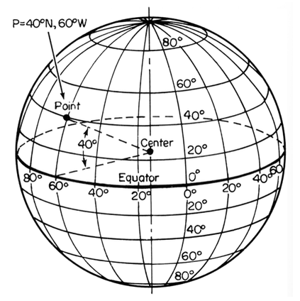
Fig 1.23 Locating the position of a place
Calculating Local Time
Calculate local time
The Earth rotates on its own axis once every 24 hours (1 day). Since the Earth turns 360° in 24 hours, it turns 1° in 4 minutes (24×60/360 = 4 minutes). All places along a given meridian will experience midday sun at the same time. Time recorded along a given meridian is known as local time. Since longitude 0° is called Prime Meridian or Greenwich Meridian, the local time at longitude 0° is called Greenwich Mean Time (GMT). It is the reference time for all local times across the globe. When it is 12.00 noon on the Greenwich meridian, it will be 1.00 pm at a place 15°E or 11.00 am at a place 15°W.
Local mean time can easily be calculated at any place once the longitude is known because if the Earth completes one rotation (360°) in 24 hrs, it passes through 15° of longitude in 1 hour, and 1° in 4 minutes.
Example 1
Find the local time for Musoma (34°E) in Tanzania, when it is 12 noon for Kinshasa (15° 30’) in DRC.
Solution
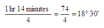
(i) Find the difference in degrees of longitude between Musoma and Kinshasa: 34° - 15° 3’ = 18° 30’ = 18.5°
(ii) Find the difference in time:
The difference in time between the two places is 18.5/15, which gives 1 hr 14 minutes.
(iii) Since Musoma is to the East of Kishasha, its local time should be ahead of that of Kinshasa. Therefore, the local time for Musoma is 12.00 noon plus 1 hr 14 minutes which is 1.14 pm.
On the other hand, given the time difference between two places and the longitude of one of them, we can calculate the longitudinal position of the second place.
Example 2
Kinshasa is 15° 30’E and it is 1 hr 14 min behind the time of Musoma. Find the longitudinal position of Musoma.
Solution.
(i) The difference in time between Kinshasa and Musoma is 1 hr 14 min.
(ii) The difference in degrees of longitude between Kinshasa and Musoma is:
(iii) Since the time for Kinshasa is behind that of Musoma, then Musoma must be to the east of Kinshasa. Therefore, the longitudinal position for Musoma = 15° 30’ + 18° 30’ = 34°E
We can also find the time and longitudinal position of two places located on either side of the Greenwich meridian.
Example 3
The local time for place, X, located 15°W is 11 am. Find the local time for a place, Y, located 5°E.
Solution,
(i) Find the difference in degrees of longitude between X and Y:
15° + 5° = 15°
(ii) Find the difference in time:-
The difference in time between the two places is 15/15, which gives 1 hr
(iii) Since Y is to the east of X, its local time should be ahead of that of X. Therefore, the local time for Y is 11.00 am plus 1 hr, i.e., 12.00 noon.
Time and Time Zone
Define time and time zone
Time refers to a period that is used for an activity. It is normally measured in seconds, minutes, hours, days, weeks, months, years, decades, centuries or millenniums. A time zone refers to a zone where standard time is accepted throughout a longitudinal zone 15° in width.
Essence of Time and Time Zone
Explain the essence of time and time zone
There would be problems in telling time if every place had its own time set according to the local time. For example, there would be a great confusion in railways and airways timetables or radio programmes if they had to show different times, each referring to one particular place within a small area. In order to avoid this problem, different stretches of land take their time from agreed meridians. The time adopted is known as standard time. For example, Tanzania, Kenya, Uganda, Ethiopia, Djibouti and Somalia use the same standard time. This is commonly referred to as the East African Standard time. In East Africa, standard time is taken from 45°E. When a whole stretch of land keeps the same standard time, that stretch forms a time zone. Standard time is the time of the longitude (meridian) near the centre of the time zone.
Variation of Standard Time in a Single Country
Explain variation of standard time in a single country
There are 24 time zones in the world. The Greenwich Meridian (GMT) is the starting point for dividing the globe into 24 time zones. The standard time for Greenwich is known as Greenwich Mean Time. Countries with large stretches of land like Canada, USA, and Russia have several time zones. They have different standard times for different regions within the same country.
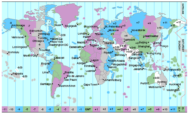
Fig 1.24 Time zones
International Date Line
Define International Date Line
The International Date Line is the line where date is changed or where the calendar day begins. This line roughly follows the 180° meridian east (or west) of Greenwich. It is also known as the line of demarcation.
When you cross the International Date Line from east to west, you lose a day, and if you cross the line from west to east, you gain a day. If at Greenwich it is noon on Tuesday, a place 90°W would be 6.00 am on Tuesday; at a place 180°W it would be midnight on Monday. On the other hand, a place 90°E would be 6.00 pm on Tuesday and at place 180°E it would be midnight on Tuesday.
Location of International Date Line
Locate International Date Line
The International Date Line, established in 1884, passes through the mid-Pacific Ocean and roughly follows a 180° longitude. It is located halfway round the world from the prime meridian (0° longitude), established in Greenwich, England, in 1852. Greenwich is the reference point of time zones. The line zigzags at some points to enable all parts of a country keep the same date. If the line was to cross a country, island or groups of islands belonging to the same country, then that country would record two different dates on the same day. This problem was avoided by diverting the line at some points (Fig 1.25).
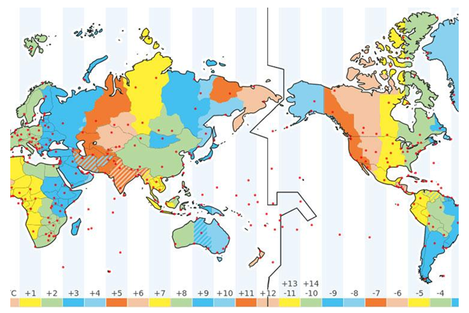
Fig 1.26 International Date Line
Subscribe to:
Post Comments
(
Atom
)


No comments :
Post a Comment